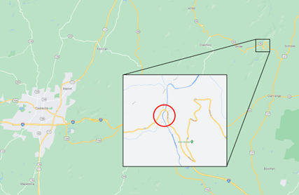
Fentress Co. SR-85
Bridge over East Fork Obey River (L.M. 5.67) (PIN 124061.00)Review Dates: June 14th - 15th, 2023
Deadline to Submit Letter of Interest: June 6th, 2023
Letter of Interest - Fentress Co. 124061.00 - Constructability Review
Note: Participation in this review is voluntary, non-compensable, and will not prevent you from submitting a bid for the project. Anything you choose to share will remain in confidence. Any Contractor that is prequalified with TDOT's Construction Division may request participation by completing and submitting a Letter of Interest to Shawna Smith at Shawna.B.Smith@tn.gov.

Project Location
The project is located north of Clarkrange, TN, in Fentress County. The subject bridge is approximately 5.3 miles west of the intersection of State Route 85 with State Route 28.
Project Description
The project includes the removal of the existing bridge and construction of a new bridge on a new alignment, approximately 600’ south of the existing bridge. State Route 85 carries a 2025 ADT of 1,300 vehicles per day and the proposed design speed is 30 MPH for the project.
The typical section on State Route 85 and the proposed bridge will consist of two (2) eleven (11) foot travel lanes and six (6) foot shoulders. This typical will taper down to no shoulders at each end of the project, to match the existing widths.
The proposed structure is a seven (7) span, concrete bridge with a total length of 700’. The entire alignment of the bridge is in a horizontal curve as well as sag vertical curve. The length of five (5) of the spans is 104’-10” and the approach spans are 104’-0” and 71’-10”. The vertical clearance under the bridge varies from beginning to end, with the span over East Fork Obey River at approximately 90’ above the stream.
Due to the realignment of State Route 85, side roads will need to be developed on both approaches to tie back into the current alignment and maintain access to properties to the north. Three (3) driveways will also be required as part of the project, with the easternmost driveway requiring coordination with the embankment of State Route 85 as it runs parallel to the route and will be at the bottom of the proposed fill.
Due to steep existing slopes and stability analysis of the proposed slopes, roadway cuts will be no steeper than 2.5:1 and fill slopes will need to be graded solid rock (GSR) at either 1.5:1 or 2:1.
Challenges
- Environmental impacts
- Timeframe restrictions
- Haul road requirements
- Transporting and setting beams
- Traffic control
- Utilities